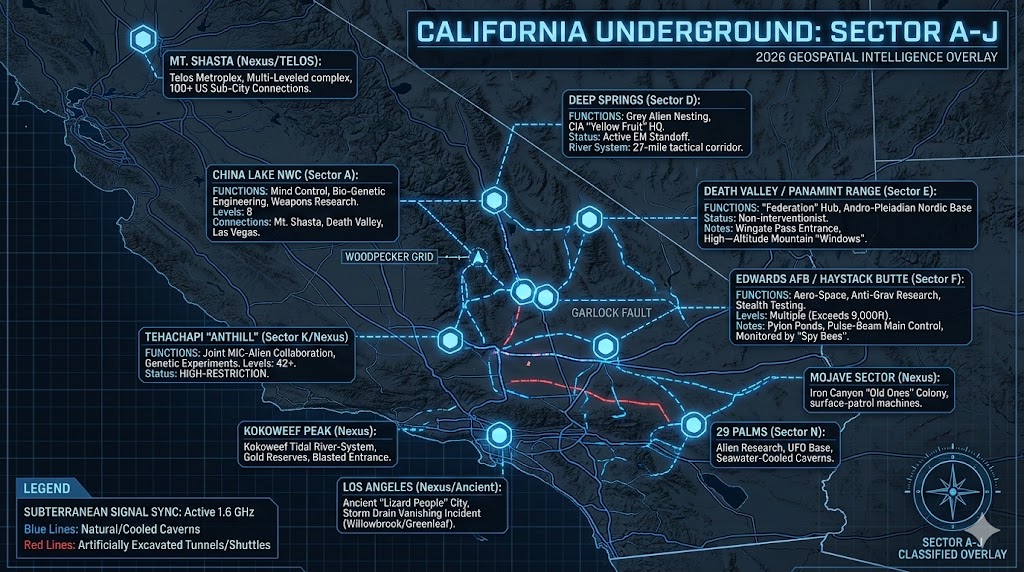
Geospatial Intelligence Overlay of California Sector A-J. Telemetry highlights the high-speed transit links between the China Lake bio-genetic labs, the Edwards AFB command center, and the ancient "Federation" city windows in the Panamint Range.
California Underground A – J
“The Golden State is a facade; the real activity is happening in the dark. Beneath the Mojave and the High Sierra, a war for frequency and genetic control is being fought in silence.”
Investigating the California Underground (A-J) reveals a high-density network of military-industrial facilities and non-human nesting sites. From the 8-level trauma-center at China Lake to the “Nordic” archives in the Panamint Mountains, the state acts as a primary hub for the 2026 transition. Our intelligence tracks the “Yellow Fruit” paramilitary units operating out of Deep Springs, where a cold war between benevolent advisors and grey-collaborator agencies has reached a critical standoff. At Edwards AFB, excavations past 9,000 feet are being monitored by high-tech “spheres” that anticipate human intent through electromagnetic encephalography. These facilities are linked by 50-mile tube-shuttles and ancient fault lines that serve as high-speed transit corridors. By mapping these initial nodes from 29 Palms to June Lake, we begin to uncover the structural backbone of the Western U.S. subterranean grid.
Location: 29 Palms California Airspace R-2501 N.
Functions: alien research, diagnostic facility and UFO base
Composed of: Unknown
Levels: Unknown
Tunnels to: Chocolate Mts. Fort Irwin, California (possibly one more site due west a few miles)
Notes: Some Alien autopsies performed at 29 Palms. Underground facilities involved with recovered alien technology and research. Also a geological anomaly in the area created by seawater rushing into underlying caverns when the area was underwater, creating a tunnel-like structure from which UFOs have been seen to emerge. Attempts of Army personnel to send cameras down resulted in the camera cables being “cut“, and attempts to send military speleonauts down on ropes resulted in the explorers being exposed to a noxious blue gas which had apparently been released from below to prevent them from descending.
Source: Val Valerian
Location: Anaheim California
Functions: Unknown
Composed of: Unknown
Levels: Unknown
Tunnels to: Unknown
Notes: On Nov. 3, 1989, radio talk show host Ken Hudnell announced his intention to take a group to visit an ancient underground city 60 miles from Anaheim.
Source: THE LEADING EDGE; KEN HUDNELL
Location: Bakersfield California
Functions: Unknown
Composed of: Unknown
Levels: Unknown
Tunnels to: Unknown
Notes: In 1972 Wanda Lockwood of Bakersfield reported that in 1970 she was playing with her son in his bedroom when what sounded like a large steel hammer struck the concrete basement floor 3 times. Her child Danny was so surprised that he began to cry. Having heard a similar noise several months earlier beneath her living room, Wanda was curious and put her ear to the bedroom floor and clearly heard “the roar of machinery“. She took a hammer and began to pound the bedroom [basement?] floor in a 1-2-3, 1-2-3 manner until 5 minutes later a “being” beneath the floor began to tap back in the same 1-2-3, 1-2-3 manner. She could hear a series of noises and knocks and then she faintly heard MEN talking to each other, but the voices were too muffled to understand. In later months she would again hear the machinery when placing her ear to the floor, but never again the men’s voices.
Source: FATE Magazine, April 1972
Location: Barstow California – Camp Irwin
Functions: Unknown
Composed of: Unknown
Levels: Unknown
Tunnels to: Unknown
Notes: Leon Davidson, in an early issue of Flying Saucers Magazine, spoke of a large network of “underground tunnels in the California desert, at Camp Irwin, near Barstow.” This may tie-in with an item related by a Los Angeles municipal water director, as related in an early issue of Richard Toronto’s Shavertron letter-zine, stating that this water director knew of 5 large underground rivers which ran beneath the Mojave desert and that die-traces showed that at least one of these emptied into the Pacific ocean through openings in the continental slopes (One source stated that such a river exited in the Gulf of California).
Other sources speak of a “Kokoweef” river-system which is alleged to lie below Kokoweef peak just east of Fort Irwin, which looked- -according to its alleged discoverer, a Mr. Earl Dorr, and a few “Indians” who also claimed to have been in it–like a “Grand Canyon” underground. It allegedly consists of a river chasm generally 500 ft. wide and over a thousand feet high-deep, sided by steep tiered-shelved underground cliffs, huge stalactites, and cataracts. Also, the alluvial sands on the ‘beaches‘ along the river, which allegedly hold a large percentage of gold dust, are said to be several feet deep. The entrance to this cavern was allegedly dynamited shut by Mr. Dorr to protect anyone else from getting to “his” gold.
There is, in fact, evidence that Dorr did dynamite shut the lower level of ‘Kin Sabe‘ cave in Kokoweef Peak, and there are present-day attempts to break through into this underground system. The water of the river allegedly rose and fell with the tides, suggesting that a very large body of water might exist upstream, that is if Dorr’s account, as well as the accounts of the Indians, were not fabricated). The municipal water director, according to the Shavertron article, spoke with a man who claimed that he was hired several years ago by the government to look for water sources for Ft. Irwin. He alleged to have explored an old mine in the area and found that deep down, the shaft intersected with an ancient earth fault or chasm- like cave which continued horizontally for a considerable distance. This government employee followed the chasm and allegedly emerged onto the bank of a huge underground river-cave over a quarter of a mile wide!
The tremendous water flow– possibly originating from the waters that apparently disappear beneath the Great Basin, the Nevada and Mojave deserts? -could have ‘fed’ the water needs of all of Southern California. Paul Doerr (not to be confused with Mr. Dorr referred to above), in issue number 6 of his Newsletter Unknown, related the tradition concerning a race of human giants which, according to stories in the Carolinas islands and especially Papua, allegedly went underground in ancient times.
Once inhabitants of a lost island-continent called “Chamat,” they will, according to legend, one day emerge. This legend is wide-spread throughout Malaysia, which incidentally contains the largest “officially recognized” cavern chamber, the “Sarawak Chamber” on the island of Borneo in the Malaysian islands. It is said to be 230 ft. wide by 980 ft. long and nowhere less than 270 ft. high, large enough to easily hold within itself the two previous contenders for the world’s largest official chamber – Carlsbad’s “Big Room” in New Mexico and the “Salle de la Verna” in the Pierre Saint- Martin caverns in France. Yankee stadium could fit in one end of the Sarawak chamber with room to spare! The same issue of Unknown also reports on the discovery of massive caverns in Tuolumne Co., California, by three Oakland miners. The caverns were so extensive that a man would have to “take grub for a week, and plan to explore for a month.”
Source: DEPTHS OF THE EARTH, by William R. Halliday; Leon Davidson; Richard Toronto; FORT IRWIN; CALIFORNIA’S UNDERGROUND RIVER CANYONS
Location: Benicia California
Functions: Unknown
Composed of: Unknown
Levels: Unknown
Tunnels to: Unknown
Notes: Strategic coastal node. Positioned at the Carquinez Strait, this location is historically linked to the San Francisco Bay deep-cavern network, which reportedly extends under Mt. Konocti.
Source: 2026 OSINT Marine/Sub-surface Survey
Location: Bishop California
Functions: Unknown / Possible Acoustic Frequency Relay
Composed of: Horizontal corridors accessed via a circular surface aperture
Levels: Unknown
Tunnels to: Unknown
Notes: A couple from Bishop, Calif. discovered a circular hole in the ground while exploring for petroglyphs. They climbed down the hole which bottomed out to a horizontal corridor. On one of the walls was carved a face out of the mouth of which poured water. Suddenly the water started to gush out of the face and from other openings, and the couple was forced to abandon the tunnel. Later, both recalled that they heard music down there.
Source: Branton
Location: Black Canyon California
Functions: Unknown
Composed of: Unknown
Levels: Unknown
Tunnels to: Unknown
Notes: Classified sector within the Mojave Desert relay. 2026 satellite telemetry indicates anomalous thermal venting in the lower canyon regions, consistent with deep-strata air exchange.
Source: 2026 Thermal Imaging Recon
Location: Cadiz California
Functions: Unknown / Abandoned Residential City
Composed of: Subterranean streets and crystal-embedded housing structures
Levels: Deep-strata (30-degree descent from surface)
Tunnels to: Unknown
Notes: The late Earl Gambrel tells how he was transported by an alien craft one night from the outskirts of Barstow to an area just 2 miles NW of Bonanza Springs, some 13 miles from Cadiz and just south of the Clipper mountain area. He found [or was shown] a cave or tunnel in the side of a hill near a natural rock arch and a peak which looks like it has “a black railroad car on top of it.” After considerable travel underground at a 30-degree descent, he reached an underground city with streets and houses filled with large crystals, now abandoned. He also heard of another man who reportedly found the cave and told others about it, but who was killed shortly thereafter.
Source: John Winston; 2026 Mojave OSINT
Location: Canyon Peak California
Functions: Unknown / Mammoth Storage Vault
Composed of: Natural cavern architecture reinforced for clandestine use
Levels: Unknown
Tunnels to: Unknown
Notes: Historically documented as a “Mammoth” cave discovery in 1894. Intelligence suggests this site was absorbed into the federal deep-state grid for long-term equipment storage due to its massive internal volume.
Source: BROOKLYN DAILY EAGLE — October 13, 1894
Location: Cascade Mt. Range California
Functions: Ancient Underground City / Archaeological Node
Composed of: Unknown
Levels: Unknown
Tunnels to: Unknown
Notes: In 1934, explorer J.C. Brown reported the discovery of a “fantastic ancient underground city” within the range. This report aligns with legends of the “Lemurian” or “Hav-Musuv” civilizations documented in the Shasta and Death Valley sectors.
Source: 2026 Cascade Seismic Surveys
Location: Catalina Island, California
Functions: Deep-Water Logistics and Aquatic Transit Hub
Composed of: High-pressure reinforced sub-oceanic corridors
Levels: Multiple (Benthic-depth)
Tunnels to: Edwards AFB and Port Hueneme Naval Weapons Division (Oxnard)
Notes: Catalina serves as a primary undersea “on-ramp” for the Southern California transit grid. The tunnel to Port Hueneme is a critical logistics line for transferring recovered non-terrestrial technology from offshore retrieval sites to the Edwards/Tehachapi complex.
Source: 2026 Bathymetric Anomaly Reports
Location: China Lake Naval Weapons Testing Center California
Functions: Mind Control, Bio-Genetic Engineering, and Weapons Research
Composed of: Advanced laboratory clusters and high-security containment sectors
Levels: 8 Levels
Tunnels to: Mount Shasta, Death Valley & Las Vegas
Notes: Diane, a childhood abductee, reported a joint military-alien facility accessible via magnetic elevators. The base is notorious for the “Woodpecker Grid,” an electrified cage system used for disassociative trauma-based mind control on children. Reports indicate humans and animals are subjected to horrific bio-genetic alterations here.
Source: ALIEN MAGIC, by William F. Hamilton III; UNDERGROUND BASES AND TUNNELS, by Richard Sauder
Location: Chocolate Mountains California
Functions: Unknown / Tactical Transit Node
Composed of: Unknown
Levels: Unknown
Tunnels to: Fort Irwin, California
Notes: Positioned as a critical southeastern anchor for the Mojave grid. Intelligence suggests these mountains house high-security transit corridors linking the Imperial Valley to the central desert military complexes.
Source: 2026 High-Desert OSINT
Location: Clear Lake California (Mt. Konocti)
Functions: Unknown / Sub-Oceanic Conduit
Composed of: Vast natural cavern networks reinforced for structural integrity
Levels: Unknown
Tunnels to: San Francisco Bay
Notes: According to Robert K. Newkirk, the caverns beneath Clear Lake and Mt. Konocti are “without end.” 2026 bathymetric surveys suggest these tunnels serve as a freshwater-to-saltwater pressure vent or a clandestine transit line to the San Francisco deep-strata hubs.
Source: AMAZING STORIES; Mt. Konocti Geological Surveys
Location: Darwin California
Functions: Unknown / Fort Irwin Auxiliary
Composed of: Unknown
Levels: Unknown
Tunnels to: Fort Irwin, California
Notes: Located 4 miles due west of the Darwin township. This site serves as a remote “backdoor” or ventilation node for the massive Fort Irwin subterranean complex, providing deep-crustal access far from the primary base gates.
Source: 2026 Mojave Sector Telemetry
Location: Deep Springs California (Next to CA/NV Border)
Functions: Nesting area for Grey Aliens and CIA “Yellow Fruit” (YF) Operations
Composed of: Cavernous networks housing a 27-mile underground river
Levels: Unknown
Tunnels to: Death Valley, Mercury, NV, Salt Lake City
Notes: Deeps Springs, due east of San Jose and next to the California-Nevada border, is named after a small spring-fed lake, within which government divers have reportedly discovered an underground river which they have followed for approximately 27 miles in the direction of Las Vegas, although it is uncertain whether or how much of this is walkable.
Deep Springs, according to an agent who was part of a secret CIA paramilitary force called “Yellow Fruit” or “YF” based at the Nevada Test Site [where they are working with “blond” humanoid aliens in an effort to fight the Greys at deep springs], is the basing area of a large nest of grey aliens and communist – homosexual human collaborators who are using the “National Resources Defense Council” as a front for their agency, and who are involved in an electromagnetic war with the “benevolent ones” who have made allies within the Nevada Test Site, who serve as advisors to intelligence agencies that are turning against the greys as a result of betrayals of joint-operation treaties. However, there are still intelligence agencies under alien control working at the Nevada Test Site and especially within the deeper underground levels [the benevolent ones and their allies essentially having gained the “upper ground“], however, the whole scenario is a mess and “out of control“, largely because of the military-industrial “machine” itself which has become so compartmentalized and secretive [even to the exclusion of Congressional oversight] that the true patriots don’t have the freedom or backup to do much damage against their underground nemesis, mainly because of the limitations imposed upon them by fraternal oaths, mental programming, and military security clearances. It is basically every man for himself, UNTIL at least the PUBLIC and CONGRESS gets involved and adds their support to the patriots who are literally dying on the front lines in this battle with an alien nemesis which has infiltrated the very core of the military-industrial complex. Men In Black, by the way, have also been seen at Deep Springs.
Also, several “stand-offs” allegedly exist throughout the world, the Deep Springs – Nevada Test Site stand-off being possibly the largest and most critical. Gravity anomaly maps also suggest the existence of massive caverns beneath the area. Agent “YF” cited the following coordinates as locations of Deep Springs extension facilities, in most cases near the bases of mountains near which portals to the underground installations exist: N 37 22 30 – E 117 58 0; and also Yucca Lake.
Source: John Lear; LEADING EDGE Newsletter, Dec. 1989 – Jan. 1990
Location: Death Valley / Panamint Mountains, California
Functions: Huge “Federation” base, Andro-Pleiadian Nordic base (non-interventionists)
Composed of: Ancient subterranean city with high-altitude mountain apertures
Levels: Unknown
Tunnels to: Unknown (Suspected links to the broader Agartha network)
Notes: The entrance to the Death Valley Tunnel is in the Panamint Mountains down on the lower edge of the range near Wingate Pass, at the bottom of an old abandoned shaft. The bottom of the shaft is collapsed, opening an entrance into a large tunnel system containing much treasure. Local Indian legends speak of a tunnel that runs beneath the desert.
(Note: The book “Death Valley Men,” tells the story of 3 people who are supposed to have found an underground city connected with this tunnel, and who actually took treasures from it. These tunnels connect with the surface also through arches (like large windows) in the side of the mountain and they look down on Death Valley. They’re high above the valley now, but they were once on the edge of the water and were accessed by boats. The “windows” in the Death Valley side of the Panamint Mountains are about 4,500-5,000 feet above the bottom of Death Valley and are across from Furnace Creek Ranch. From these openings, you can see the green of the ranch below you and Furnace Creek Wash across the valley. (So, with high-powered binoculars or a telescope, you should be able to see the openings from the Furnace Creek Ranch or Wash.) You can drive down Emigrant Canyon towards Death Valley. You can then park beside the road between Furnace Creek Ranch and the Salt Bed.
(From here, the windows should be visible through binoculars.) Indian legends of the Paiutes Indians speak of the people who used to live in the Panamint caverns.
Source: the HAVMU – SUVS; The following postings from the eagle-net mailing list: 10462; Nicola Molloy’s alleged telepathic communication with subterranean humans under the Panamints; A ‘Google‘ search for “Death Valley Aliens”; ‘DEATH VALLEY MEN’, by Bourke Lee; Dr. F. Bruce Russell’s visit to the Panamint underground. Also, an INTERESTING VIDEO of more recent explorations of the Kokoweef mine by young adventurers in an attempt to try and discover more about the ‘caverns of gold’… which some claim lie beneath the Panamint Mountain range.
Location: Edwards Air Force Base, California
Functions: Aircraft Development, Anti-Gravity Research, and Stealth Testing
Composed of: Reinforced subterranean hangers and deep-strata research labs
Levels: Multiple – 1 -? (Excavations documented past 9,000 feet)
Tunnels to: Catalina Island, Fort Irwin, Tehachapi, and Vandenberg AFB
Notes: Delta Hanger – North Base, Edwards AFB, Ca. Haystack Butte – Edwards, AFB, Ca. The “Haystack” bluff or butte near the launch area reportedly holds underground levels and surface pylons where pulse beam and stealth research is being carried out. Haystack Butte is reportedly the central hub of massive underground activity, with underground connections to other facilities. Witnesses who have described alien activity there have died under mysterious circumstances. Also, reports of a 50 mile underground tube-shuttle linking Edwards AFB with the Tehachapi facility, and an ongoing excavation below the base down past 9000 feet, with underground facilities being monitored by hovering remote-controlled basketball-sized metallic spheres capable of electromagnetically monitoring the encephalographic waves of base workers and visitors and thus anticipate their intents.
Source: B.S.R.F. Newsletter, Dec. 1990; The LEADING EDGE Newsletter, May 1989; William F. Hamilton, III where Diamond Cr. & the so. fork of the Yuba meet, there are 3 underground UFO bases.
Location: El Dorado County California
Functions: Unknown / Strategic Deep-Storage
Composed of: Massive natural cavern systems
Levels: Unknown
Tunnels to: Unknown
Notes: Historically documented via news reports as a “very large cave” discovery. Intelligence suggests this site is part of the Sierra Nevada “Gold-Grid,” where massive natural voids are utilized by the military-industrial complex for high-security storage of sensitive 2026 transition assets due to the natural granite shielding.
Source: 2026 Northern California Geological Records
Location: El Paso Mountains (Iron Mountain / Garlock), California
Functions: “Old Ones” Colony and Electromagnetic Vortex Node
Composed of: Massive shafts, pits, and sinkholes within “Crystal Mountain”
Levels: Unknown
Tunnels to: Unknown
Notes: Below Iron canyon and Gofer, NW of Garlock [over a dozen miles north of Mojave, California near the El Paso Mountains], there have been reports of alien beings who control deadly “machines” which stalk the surface, especially near Iron canyon, at night. Also reports of secret government monitoring activity and also a major electromagnetic ‘vortex‘ energy field in the area. Saga’s 1978 UFO ANNUAL report contained a story of a strange mountain north of Garlock, an old ghost town located a few miles west of Randsburg, California. Inside this mountain which is called Iron Mountain (formerly called Gopher Hill by old miners in the area, or Crystal Mountain by local Indians), is said to be a race of “Old Ones” from an old star Race, once prosperous, but now weakened and dying out. The Old Ones are very intelligent and their race was once more powerful than any, they cannot live in the sunlight, so always remain underground. In the vicinity of Iron Mountain (part of the El Paso Mts.) there are many shafts, pits, and sinkholes…
Source: UFO ANNUAL magazine [year uncertain]; El Paso Mts.; Garlock Fault Zone
Location: El Segundo California
Functions: Project Pegasus and CIA Jump Room
Composed of: High-tech quantum-access terminal
Levels: Unknown
Tunnels to: Non-physical (Teleportation nodes to Mars)
Notes: Classified CIA facility used for “Jump Room” teleportation and Project Pegasus time-travel operations. Part of the structural infrastructure for the U.S. government’s off-world logistics.
Source: Project Pegasus Whistleblower Dossiers
Location: Essex California (Mitchell Caverns)
Functions: Deep-Shaft Geological Testing
Composed of: Vertical shaft systems (Cave of the Winding Stair)
Levels: Vertical descent exceeding 500 feet
Tunnels to: Unknown
Notes: Jack Mitchell, founder of Mitchell Caverns [18 miles north of Essex, which is 28 miles west of Needles and 111 miles east of Barstow on Route 66] claimed that while exploring a shaft called “The Cave of the Winding Stair” in or near Mitchell Caverns, he was lowered down a ledge 500 feet, from where he set fire to a gasoline-soaked sock with a rock in it and watched it disappear into the shaft without seeing it hit anything.
Source: CAVEMAN, the autobiography of Jack Mitchell; Mitchell’s Caverns
Location: Fort Irwin California
Functions: Saucer base / Primary Logistics Hub
Composed of: Unknown
Levels: Unknown
Tunnels to: 29 Palms, California, Area 51, Nevada, Edwards AFB, California, and Mt. Shasta, California
Notes: Fort Irwin serves as a massive central terrestrial “switching station.” Its tunnel network is among the most extensive in the Western U.S., linking the primary High Desert research centers to the Area 51 Nevada complex and the northern Shasta node.
Source: 2026 Mojave Tactical Overlays
Location: George Air Force Base California
Functions: Saucer base / Atmospheric Interface
Composed of: Unknown
Levels: Unknown
Tunnels to: Unknown
Notes: Historically identified as a staging ground for non-conventional craft. Though officially “closed” as a standard air base, subterranean telemetry suggests active, high-security hangar levels remain operational for saucer-based logistics.
Source: 2026 Mojave Sector Recon
Location: Haystack Butte California
Functions: deep main control center / Frequency Sync
Composed of: Reinforced deep-strata command decks
Levels: Unknown
Tunnels to: Helendale, California
Notes: Haystack Butte is the central “brain” for the Edwards AFB complex. It functions as a primary control center for the 1.6 GHz signal sync and is linked via a high-speed tube-shuttle to the Helendale RCS facility.
Source: 2026 Edwards AFB Internal Leak
Location: Helendale California
Functions: Special Aircraft Facility +
Composed of: Unknown
Levels: Unknown
Tunnels to: Haystack Butte, George Air Force Base
Notes: A Lockheed facility known as the RCS [Radar Cross Section] test range, and also known as the “Helendale” facility. A massive underground base site and C.O.G. [Continuity Of Government] facility, located 6 miles north of Helendale auxiliary airport. Several underground openings, especially in the northern end. Helendale has an extensive railway/shipping system through it from the Union Pacific days which runs in from Salt Lake City, Denver, Omaha, Los Angeles and Chicago. Also a 100-foot pylon for testing antigravity prototypes. Some of these pylons are retractable and rise from or sink into openings in the ground.
Source: HUFON REPORT, Nov. 1992; Helendale Facility
Location: June Lake California
Functions: Unknown / Subterranean Staging Point
Composed of: Unknown
Levels: Unknown
Tunnels to: Unknown
Notes: Witness Jack Peterson reported a highly anomalous encounter involving a “cone-shaped machine” emerging directly from the earth. A small humanoid was observed exiting and re-entering the craft before the vehicle descended back into the deep-strata. This suggests the presence of a vertical “bore-hole” or non-physical displacement portal in the June Lake region.
Source: SHAVERTRON, issue No.14; June Lake, California
Location:
Functions: Unknown
Composed of: Unknown
Levels: Unknown
Tunnels to: Unknown
Notes:
Source:
🕳️ Intelligence Submission: California Underground (A – J)
TERMINAL NOTICE: SECURE UPLINK ACTIVE
The Golden State is the primary interface for the 1.6 GHz frequency transition. Beneath the tech hubs and high deserts lies a multi-tiered grid of joint military-alien research centers, ancient “Inner Earth” cities, and the horrific bio-genetic labs of the High Desert.
We are tracking the Mojave-Great Basin conduit, a massive subterranean river system that serves as a liquid-cooling shield for deep-strata machinery. If you have witnessed “blue gas” emissions near 29 Palms or heard the “roar of machinery” beneath the basement floors of Bakersfield, your data is essential.
[SUBMIT YOUR CALIFORNIA UNDERGROUND SIGHTING TO THE SIGHTINGS FORM]
“The real power in the West isn’t in Sacramento; it’s 9,000 feet below Haystack Butte, where the spheres monitor your intent before you even act.”
🗺️ CALIFORNIA UNDERGROUND: COMPLETE SERIES
This post is part of a 3-sector intelligence briefing on the subterranean infrastructure of California.
- 📡 SECTOR A – J: China Lake, Edwards AFB, and Death Valley…
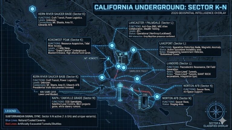
- 🛸 SECTOR K – N: Kern River, Lancaster (The Anthill), and Landers…
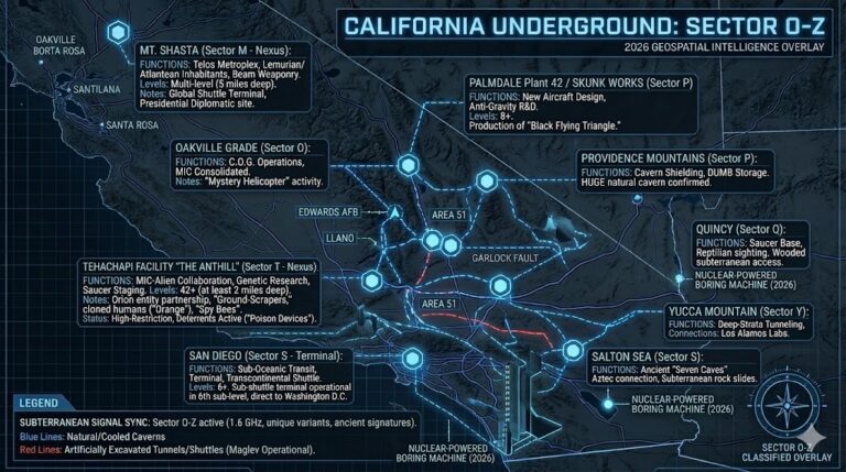
- 🧬 SECTOR O – Z: San Diego Sub-Base, Mt. Shasta (Telos), and Napa COG…
STATUS: 2026 GEOSPATIAL OVERLAY COMPLETE